F. REDUCTION FOR PUBLIC PURPOSE
When an existing setback is reduced because of conveyance to a federal, state or local government for a public purpose and the remaining setback is at least 50 percent of the required minimum setback for the district in which it is located, then that remaining setback will be deemed to satisfy the minimum setback standards of this Ordinance.
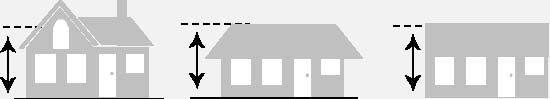
§4.2.4 BUILDING HEIGHT Building Height
Building height refers to the vertical distance between the base flood elevation and: 1) the average height level between the eaves and ridge line of a gable, hip or gambrel roof; 2) the highest point of a mansard roof; or 3) the highest point of the coping of a flat roof.
A. FENCES OR WALLS
In the case of fences or walls, height shall be measured from ground level on the higher side of the fence or wall.
B. EXCEPTIONS TO HEIGHT LIMITS
Unless otherwise expressly stated, the height limitations of this Ordinance shall not apply to any of the following:
-
Farm buildings in any Agricultural zoning (A) district;
-
Electrical power transmission lines;
-
Belfries, cupolas, spires, domes, monuments, flagpoles, chimneys, radio/television receiving antennas or chimney flues; or
-
Bulkhead, elevator, water tank, or any other similar structure or necessary mechanical appurtenance extending above the roof of any building, if such structure does not occupy more than 33a percent of the area of the roof.
§4.2.5 BUILDING COVERAGE
Building coverage refers to the area of a lot covered by buildings (principal and accessory) or roofed areas, as measured along the outside wall at ground level, and including all projections, other than open porches, fire escapes, canopies and the first 2 feet of a roof overhang.
Article 4.3 AG25 Resource Management District
§4.3.1 DESCRIPTION
The AG-25, Resource Management district implements the Resource Management (Rural Landscape-Agricultural Area) policies of the Comprehensive Plan.
§4.3.2 USE REGULATIONS
Uses are allowed in the AG-25 district in accordance with the Use Regulations of Chapter 6.
§4.3.3 DENSITY/INTENSITY AND DIMENSIONAL STANDARDS
All residential and nonresidential development in the AG-25 district shall be subject to the following density, intensity and dimensional standards:
|
AG-25 DENSITY/INTENSITY AND DIMENSIONAL STANDARDS |
|
MAXIMUM DENSITY [1] |
1 dwelling unit per 25 acres |
|
MINIMUM LOT AREA |
1 acre |
|
MINIMUM LOT WIDTH |
135 feet |
|
MINIMUM SETBACKS |
|
Front/Street Side |
50 feet |
|
Interior Side |
15 feet |
|
Rear |
30 feet |
|
OCRM Critical Line |
50 feet |
|
MAXIMUM BUILDING COVER |
30% of lot |
|
MAXIMUM HEIGHT |
35 feet |
[3] On tracts of 100 or more acres, where lots ranging from 1 to 3 acres are created, a bonus of one dwelling shall be allowed on the residual area of the parent tract.
§4.3.4 OTHER REGULATIONS
Development in the AG-25 district shall comply with all other applicable regulations of this ordinance, including the development standards of Chapter 9. All waterfront property subdivided after April 21, 1999 shall be subject to the provisions of the Waterfront Development Standards contained in Article
4.22 of this Chapter.
§4.3.5 ONE TIME SUBDIVISION OF NON-CONFORMING LOT OF RECORD EXISTING PRIOR TO APRIL 21, 1999
A one time subdivision creating one lot from a non-conforming lot of record (lot existing prior to April 21, 1999) shall be allowed, if each lot resulting from the subdivision meets the minimum lot area requirement of the AG-25 Zoning District.
Article 4.4 AG-15 Agricultural Preservation District
§4.4.1 DESCRIPTION
The AG-15, Agricultural Preservation district implements the Agricultural Preservation (Rural Landscape-Agricultural Area) policies of the Comprehensive Plan.
§4.4.2 USE REGULATIONS
Uses are allowed in the AG-15 district in accordance with the Use Regulations of Chapter 6.
§4.4.3 DENSITY/INTENSITY AND DIMENSIONAL STANDARDS
A. DENSITY/INTENSITY AND DIMENSIONAL STANDARDS TABLE
All residential and nonresidential development in the AG-15 district shall be subject to the following density, intensity and dimensional standards:
|
AG-15 DENSITY/INTENSITY AND DIMENSIONAL STANDARDS |
|
MAXIMUM DENSITY |
1 dwelling unit per 15 acres |
|
MINIMUM LOT AREA |
3 acres |
|
MINIMUM LOT WIDTH |
135 feet |
|
MINIMUM SETBACKS |
|
Front/Street Side |
50 feet |
|
Interior Side |
15 feet |
|
Rear |
30 feet |
|
OCRM Critical Line |
50 feet |
|
MAXIMUM BUILDING COVER |
30% of lot |
|
MAXIMUM HEIGHT |
35 feet |
B. DEVELOPMENT ALONG CRITICAL LINE
The area of a parcel in the AG-15 district within 1000 feet of the OCRM Critical Line has a Maximum Density of 1 dwelling unit per 3 acres with a minimum lot area of 3 acres. The remaining acreage of the parcel (more than 1000 feet from the OCRM Critical Line) maintains a density of 1 dwelling unit per 15 acres.
§4.4.4 OTHER REGULATIONS
Development in the AG-15 district shall comply with all other applicable regulations of this Ordinance, including the development standards of Chapter 9. All waterfront property subdivided after April 21, 1999 shall be subject to the provisions of the Waterfront Development Standards contained in Article
4.22 of this Chapter.
§4.4.5 ONE TIME SUBDIVISION OF NON-CONFORMING LOT OF RECORD EXISTING PRIOR TO APRIL 21, 1999
A one time subdivision creating one lot from a non-conforming lot of record (lot existing prior to April 21, 1999) shall be allowed, if each lot resulting from the subdivision meets the minimum lot area requirement of the AG-15 Zoning District.
Article 4.5 AG-10 Agricultural Preservation District
§4.5.1 DESCRIPTION
The AG-10, Agricultural Preservation district implements the Agricultural Preservation (Rural Landscape-Agricultural Area) policies of the Comprehensive Plan.
§4.5.2 USE REGULATIONS
Uses are allowed in the AG-10 district in accordance with the Use Regulations of Chapter 6.
§4.5.3 DENSITY/INTENSITY AND DIMENSIONAL STANDARDS
A. DENSITY/INTENSITY AND DIMENSIONAL STANDARDS TABLE
All residential and nonresidential development in the AG-10 district shall be subject
|
AG-10 DENSITY/INTENSITY AND DIMENSIONAL STANDARDS |
|
MAXIMUM DENSITY |
1 dwelling unit per 10 acres |
|
MINIMUM LOT AREA |
1 acre |
|
MINIMUM LOT WIDTH |
135 feet |
|
MINIMUM SETBACKS |
|
Front/Street Side |
50 feet |
|
Interior Side |
15 feet |
|
Rear |
30 feet |
|
OCRM Critical Line |
50 feet |
|
MAXIMUM BUILDING COVER |
30% of lot |
|
MAXIMUM HEIGHT |
35 feet |
B. ACHIEVING HIGHEST DENSITY
In order to achieve the highest allowed density of 1 dwelling unit per 5 acres, a request must be processed through the Planned Development process as designated in Art. 3.5 of this Ordinance.
§4.5.4 OTHER REGULATIONS
Development in the AG-10 district shall comply with all other applicable regulations of this Ordinance, including the development standards of Chapter 9. All waterfront property subdivided after April 21, 1999 shall be subject to the provisions of the Waterfront Development Standards contained in Article
4.22 of this Chapter.
§4.5.5 ONE TIME SUBDIVISION OF NON-CONFORMING LOT OF RECORD EXISTING PRIOR TO APRIL 21, 1999
A one time subdivision creating one lot from a non-conforming lot of record (lot existing prior to April 21, 1999) shall be allowed, if each lot resulting from the subdivision meets the minimum lot area requirement of the AG-10 Zoning District.
Article 4.6 AG-8 Agricultural Preservation District
§4.6.1 DESCRIPTION
The AG-8, Agricultural Preservation district implements the Agricultural Preservation (Rural Landscape-Agricultural Area) and Rural Agricultural (Rural Landscape-Rural Area) policies of the Comprehensive Plan.
§4.6.2 USE REGULATIONS
Uses are allowed in the AG-8 district in accordance with the Use Regulations of Chapter 6.
§4.6.3 DENSITY/INTENSITY AND DIMENSIONAL STANDARDS
A. DENSITY/INTENSITY AND DIMENSIONAL STANDARDS TABLE
All residential and nonresidential development in the AG-8 district shall be subject to the following density, intensity and dimensional standards:
|
AG-8 DENSITY/INTENSITY AND DIMENSIONAL STANDARDS |
|
MAXIMUM DENSITY |
1 dwelling unit per 8 acres |
|
MINIMUM LOT AREA |
1 acre |
|
MINIMUM LOT WIDTH |
135 feet |
|
MINIMUM SETBACKS |
|
Front/Street Side |
50 feet |
|
Interior Side |
15 feet |
|
Rear |
30 feet |
|
OCRM Critical Line |
50 feet |
|
MAXIMUM BUILDING COVER |
30% of lot |
|
MAXIMUM HEIGHT |
35 feet |
B. ACHIEVING HIGHEST DENSITY
In order to achieve the highest allowed density of 1 dwelling unit per 4 acres, a request must be processed through the Planned Development process as designated in Art. 3.5 of this Ordinance.
§4.6.4 OTHER REGULATIONS
Development in the AG-8 district shall comply with all other applicable regulations of this Ordinance, including the development standards of Chapter 9. All waterfront property subdivided after April 21, 1999 shall be subject to the provisions of the Waterfront Development Standards contained in Article
4.22 of this Chapter.
§4.6.5 ONE TIME SUBDIVISION OF NON-CONFORMING LOT OF RECORD EXISTING PRIOR TO APRIL 21, 1999
A one time subdivision creating one lot from a non-conforming lot of record (lot existing prior to April 21, 1999) shall be allowed, if each lot resulting from the subdivision meets the minimum lot area requirement of the AG-8 Zoning District.
Article 4.7 AGR Agricultural / Residential District
§4.7.1 DESCRIPTION
The AGR, Agricultural/Residential district implements the Agricultural Residential (Rural Landscape-Agricultural Area) policies of the Comprehensive Plan. The district is intended for application in all settlement areas.
§4.7.2 USE REGULATIONS
Uses are allowed in the AGR district in accordance with the Use Regulations of Chapter 6.
§4.7.3 DENSITY/INTENSITY AND DIMENSIONAL STANDARDS
All residential and nonresidential development in the AGR district shall be subject to the following density, intensity and dimensional standards:
|
AGR DENSITY/INTENSITY AND DIMENSIONAL STANDARDS |
|
MAXIMUM DENSITY |
1 dwelling unit per Acre |
|
MINIMUM LOT AREA |
30,000 square feet |
|
MINIMUM LOT WIDTH |
100 feet |
|
MINIMUM SETBACKS |
|
Front/Street Side |
50 feet |
|
Interior Side |
15 feet |
|
Rear |
30 feet |
|
OCRM Critical Line |
50 feet |
|
MAXIMUM BUILDING COVER |
30% of lot |
|
MAXIMUM HEIGHT |
35 feet |
§4.7.4 OTHER REGULATIONS
Development in the AGR district shall comply with all other applicable regulations of this Ordinance, including the development standards of Chapter 9. All waterfront property subdivided after April 21, 1999 shall be subject to the provisions of the Waterfront Development Standards contained in Article
4.22 of this Chapter.
§4.7.5 ONE TIME SUBDIVISION OF NON-CONFORMING LOT OF RECORD EXISTING PRIOR TO APRIL 21, 1999
A one time subdivision creating one lot from a non-conforming lot of record (lot existing prior to April 21, 1999) shall be allowed, if each lot resulting from the subdivision meets the minimum lot area requirement of the AGR Zoning District.
§4.7.6 SETTLEMENT AREAS
Settlement areas include small older crossroads communities, family lands, typical suburban style subdivisions, frontage lots along local roads, waterfront developments, and vacant land that has been subdivided for residential use but not yet built upon. The criteria for parcels to qualify for inclusion into a “Settlement Areas” are as follows:
-
Parcel size of 30 acres or less; and
-
Parcel must be located in an AG-8, AG-10, or AG-25 Zoning Districts or adjacent to lands currently zoned AGR; and
-
Parcel must be either within 1,000 feet of an existing AGR Zoning District or show the same obvious spatial characteristics of other existing AGR Zoning Districts in the agricultural area; and
-
A parcel of land may be identified as a Settlement Area as determined by the Planning Director if the property owner can demonstrate by a survey or other legally recorded plats or deeds of their property, as prepared by a registered surveyor in the State of South Carolina that their property has 30 acres or less of high land; and
-
Tax parcels are not located on Wadmalaw Island.
Article 4.8 RR-3 Rural Residential District
§4.8.1 DESCRIPTION
The RR-3, Rural/Residential district implements the Rural Residential (Rural Landscape-Rural Area) policies of the Comprehensive Plan.
§4.8.2 USE REGULATIONS
Uses are allowed in the RR-3 district in accordance with the Use Regulations of Chapter 6.
§4.8.3 DENSITY/INTENSITY AND DIMENSIONAL STANDARDS
A. DENSITY/INTENSITY AND DIMENSIONAL STANDARDS TABLE
All residential and nonresidential development in the RR-3 district shall be subject to the following density, intensity and dimensional standards:
|
RR-3 DENSITY/INTENSITY AND DIMENSIONAL STANDARDS |
|
MAXIMUM DENSITY |
1 dwelling unit per 3 acres |
|
MINIMUM LOT AREA |
30,000 sq. ft. |
|
MINIMUM LOT WIDTH |
100 feet |
|
MINIMUM SETBACKS |
|
|
Front/Street Side |
50 feet |
|
Interior Side |
15 feet |
|
Rear |
30 feet |
|
OCRM Critical Line |
50 feet |
|
MAXIMUM BUILDING COVER |
30% of lot |
|
MAXIMUM HEIGHT |
35 feet |
B. ACHIEVING HIGHEST DENSITY
In order to achieve the highest allowed density of one dwelling unit per acre, a request must be processed through the Planned Development process as designated in Art.
3.5 of this Ordinance.
§4.8.4 OTHER REGULATIONS
Development in the RR-3 district shall comply with all other applicable regulations of this Ordinance, including the development standards of Chapter 9. All waterfront property subdivided after April 21, 1999 shall be subject to the provisions of the Waterfront Development Standards contained in Article
4.22 of this Chapter.
§4.8.5 ONE TIME SUBDIVISION OF NON-CONFORMING LOT OF RECORD EXISTING PRIOR TO APRIL 21, 1999
A one time subdivision creating one lot from a non-conforming lot of record (lot existing prior to April 21, 1999) shall be allowed, if each lot resulting from the subdivision meets the minimum lot area of the RR-3 zoning district.
Article 4.9 RR-1 Rural Residential District
§4.9.1 DESCRIPTION
The RR-1, Rural Residential district implements the Rural Residential (Rural Landscape-Rural Area) and Residential/Special Management (Suburban Area) policies of the Comprehensive Plan.
§4.9.2 USE REGULATIONS
Uses are allowed in the RR-1 district in accordance with the Use Regulations of Chapter 6.
§4.9.3 DENSITY/INTENSITY AND DIMENSIONAL STANDARDS
All residential and nonresidential development in the RR-1 district shall be subject to the following density, intensity and dimensional standards:
|
RR-1 DENSITY/INTENSITY AND DIMENSIONAL STANDARDS |
|
MAXIMUM DENSITY |
2.75 dwelling units per acre |
|
MINIMUM LOT AREA |
14,500 sq. ft. [1] |
|
MINIMUM LOT WIDTH |
90 feet |
|
MINIMUM SETBACKS |
|
Front/Street Side |
50 feet |
|
Interior Side |
15 feet |
|
Rear |
30 feet |
|
OCRM Critical Line |
50 feet |
|
MAXIMUM BUILDING COVER |
30% of lot |
|
MAXIMUM HEIGHT |
35 feet |
[1] Minimum lot area of 12,500 sq. ft. if water or sewer is available.
§4.9.4 OTHER REGULATIONS
Development in the RR-1district shall comply with all other applicable regulations of this Ordinance, including the development standards of Chapter 9. All waterfront property subdivided after April 21, 1999 shall be subject to the provisions of the Waterfront Development Standards contained in Article
4.22 of this Chapter.
§4.9.5 ONE TIME SUBDIVISION OF NON-CONFORMING LOT OF RECORD EXISTING PRIOR TO APRIL 21, 1999
A one time subdivision creating one lot from a non-conforming lot of record (lot existing prior to April 21, 1999) shall be allowed, if each lot resulting from the subdivision meets the minimum lot area of the RR-1 zoning district.
Article 4.10 RSL Low-Density Suburban Residential
§4.10.1 DESCRIPTION
The RSL, Low-Density Suburban Residential district implements the Residential Low Density (Suburban Area) policies of the Comprehensive Plan.
Chapter 4 Base Zoning Districts §4.10.2 USE REGULATIONS
Uses are allowed in the RSL district in accordance with the Use Regulations of Chapter 6.
§4.10.3 DENSITY/INTENSITY AND DIMENSIONAL STANDARDS
A. DENSITY/INTENSITY AND DIMENSIONAL STANDARDS TABLE
All residential and nonresidential development in the RSL district shall be subject to the following density, intensity and dimensional standards:
-
[1]
-
70 feet without public water and/or public sewer.
|
RSL DENSITY/INTENSITY AND DIMENSIONAL STANDARDS |
|
MAXIMUM DENSITY |
4 dwelling units per acre |
|
MINIMUM LOT AREA |
8,000 square feet |
|
MINIMUM LOT WIDTH |
60 feet [1] |
|
MINIMUM SETBACKS |
|
Front/Street Side [2] |
25 feet |
|
Interior Side |
5 feet |
|
Rear |
15 feet |
|
OCRM Critical Line |
35 feet |
|
MAXIMUM BUILDING COVER |
30% of lot |
|
MAXIMUM HEIGHT |
35 feet |
[2] Front/Street Side Setback reductions of 15 feet may be approved by the Planning Director when deemed compatible with existing development patterns or setbacks shown on approved plats.
B. EXISTING NEIGHBORHOOD INFILL DEVELOPMENT
Existing neighborhood infill development shall only apply to subdivisions within the RSL Zoning District involving development within existing neighborhoods and may be approved by the Planning Director when the following conditions are present:
-
The average lot area of a lot shall be no less than the average lot area of the existing residential neighborhood (excluding multi-family dwelling units) measured within 500 feet of the boundary of the proposed subdivision in which the proposed lot is to be created, and in no case shall be smaller than 6,000 square feet, provided that public water and/or sewer service are available;
-
The infill development is a total of five acres or less in total gross acreage;
-
Meets the average lot width to depth ratio contained in this Ordinance; and
-
Each proposed lot meets the minimum lot width requirements for the RSL Zoning District and the minimum setbacks, buffers, cover and height requirements set forth in the RSL Development Standards.
§4.10.4 OTHER REGULATIONS
Development in the RSL district shall comply with all other applicable regulations of this Ordinance, including the development standards of Chapter 9. All waterfront property subdivided after April 21, 1999 shall be subject to the provisions of the Waterfront Development Standards contained in Art. 4.22 of this chapter.
§4.10.5 ONE TIME SUBDIVISION OF NON-CONFORMING LOT OF RECORD EXISTING PRIOR TO APRIL 21, 1999
A one time subdivision creating one lot from a non-conforming lot of record (lot existing prior to April 21, 1999) shall be allowed, if each lot resulting from the subdivision meets the minimum lot area of the RSL zoning district.
Article 4.11 RSM Moderate-Density Suburban Residential District
§4.11.1 DESCRIPTION
The RSM, Moderate-Density Suburban Residential district implements the Residential Moderate Density (Suburban Area) policies of the Comprehensive Plan.
§4.11.2 USE REGULATIONS
Uses are allowed in the RSM district in accordance with the Use Regulations of Chapter 6.
§4.11.3 DENSITY/INTENSITY AND DIMENSIONAL STANDARDS
All residential and nonresidential development in the RSM district shall be subject to the following density, intensity and dimensional standards:
|
RSM DENSITY/INTENSITY AND DIMENSIONAL STANDARDS |
|
MAXIMUM DENSITY |
10 dwelling units per acre |
|
MINIMUM LOT AREA |
4,000 square feet |
|
MINIMUM LOT WIDTH |
40 feet |
|
MINIMUM SETBACKS |
|
Front/Street Side |
25 feet [1] |
|
Interior Side |
5 feet |
|
Rear |
10 feet |
|
OCRM Critical Line |
35 feet |
|
MAXIMUM BUILDING COVER |
35% of lot |
|
MAXIMUM HEIGHT |
35 feet |
[1] Front/Street Side Setback reductions of 15 feet may be approved by the Planning Director when deemed compatible with existing development patterns or setbacks shown on approved plats.
§4.11.4 OTHER REGULATIONS
Development in the RSM district shall comply with all other applicable regulations of this Ordinance, including the development standards of Chapter 9.
Article 4.12 MHS Low-Density Manufactured Home Subdivision District
§4.12.1 DESCRIPTION
The MHS, Low-Density Manufactured Home Subdivision district implements the Residential Low
Density (Suburban Area) policies and the housing policies of the Comprehensive Plan.
§4.12.2 USE REGULATIONS
Uses are allowed in the MHS district in accordance with the Use Regulations of Chapter 6.
§4.12.3 DEVELOPMENT TYPES; DENSITY/INTENSITY AND DIMENSIONAL STANDARDS
All residential and non-residential uses must follow the density, intensity and dimensional standards contained in Article 4.10, RSL, Low-Density Suburban Residential District.
§4.12.4 OTHER REGULATIONS
Development in the MHS district shall comply with all other applicable regulations of this Ordinance, including the development standards of Chapter 9.
§4.12.5 ONE TIME SUBDIVISION OF NON-CONFORMING LOT OF RECORD EXISTING PRIOR TO APRIL 21, 1999
A one time subdivision creating one lot from a non-conforming lot of record (lot existing prior to April 21, 1999) shall be allowed, if each lot resulting from the subdivision meets the minimum lot area of the RSL zoning district.
Article 4.13 MHP Manufactured Housing Park District
§4.13.1 DESCRIPTION
The MHP, Manufactured Housing Park district implements the Residential Moderate Density (Suburban Area) policies of the Comprehensive Plan. It is primarily intended to accommodate manufactured housing park developments.
§4.13.2 USE REGULATIONS
Uses are allowed in the MHP district in accordance with the Use Regulations of Chapter 6.
§4.13.3 DENSITY/INTENSITY AND DIMENSIONAL STANDARDS
All development in the MHP district shall be subject to the following density, intensity and dimensional standards:
|
MHP DENSITY/INTENSITY AND DIMENSIONAL STANDARDS |
|
MAXIMUM DENSITY |
10 dwelling units per acre |
|
MINIMUM PARK AREA |
1 acre |
|
MINIMUM SETBACKS |
|
Front/Street Side |
25 feet [1] |
|
Interior Side |
5 feet |
|
Rear |
10 feet |
|
OCRM Critical Line |
35 feet |
|
MAXIMUM BUILDING COVER |
35% of lot |
|
MAXIMUM HEIGHT |
35 feet |
[1] Front/Street Side Setback reductions up to 15 feet may be approved by the Planning Director when deemed compatible with existing development patterns or setbacks shown on approved plats.
County of Charleston Zoning and Land Development Regulations [November 20, 2001]
§4.13.4 OTHER REGULATIONS
Development in the MHP district shall comply with all other applicable regulations of this Ordinance, including the development standards of Chapter 9.
§4.13.5 SUPPLEMENTAL DISTRICT STANDARDS
In addition to all other applicable provisions of this ordinance, manufactured housing parks within the MHP district shall be subject to the following standards.
A. AREA PER MANUFACTURED HOUSING UNIT SPACE
There shall be no less than 4,000 square feet of zoning lot area per manufactured housing unit space.
B. SEPARATION OF SERVICE BUILDINGS
Every service building in a manufactured housing park shall be at least 25 feet from the boundary of any other property in any residential or office zoning district. When a property line is on a natural waterway, a property line setback shall not be required.
C. ACCESS ROAD
Each manufactured housing unit space shall abut an access road that is constructed under the Charleston County Road Construction Standards and is not less than 20 feet wide.
D. DRAINAGE PLAN
A drainage plan shall be approved by the Public Works Department prior to the processing of a manufactured housing park development.
E. TEMPORARY, ACCESSORY MANUFACTURED HOUSING PARK
A temporary, accessory manufactured housing park shall be established only in connection with a construction project and shall be discontinued within 60 days after such project is completed. Written approval from the South Carolina Department of Health and Environmental Control (DHEC) shall be obtained prior to the issuance of a Zoning Permit.
Article 4.14 OR Residential Office District
§4.14.1 DESCRIPTION
The OR, Residential Office district implements the Commercial (Suburban Area) policies of the
Comprehensive Plan.
§4.14.2 USE REGULATIONS
Uses are allowed in the OR district in accordance with the Use Regulations of Chapter 6.
§4.14.3 DENSITY/INTENSITY AND DIMENSIONAL STANDARDS
All development in the OR district shall be subject to the following density, intensity and dimensional standards:
OR DENSITY/INTENSITY AND DIMENSIONAL STANDARDS
6,000 square feet
MINIMUM LOT AREA §4.14.4 OTHER REGULATIONS
|
OR DENSITY/INTENSITY AND DIMENSIONAL STANDARDS |
|
MINIMUM LOT WIDTH |
50 feet |
|
MINIMUM SETBACKS |
|
Front/Street Side |
25 feet |
|
Interior Side |
5 feet |
|
Rear |
5 feet |
|
OCRM Critical Line |
50 feet |
|
MAXIMUM BUILDING COVER |
35% of lot |
|
MAXIMUM HEIGHT |
35 feet |
Development in the OR district shall comply with all other applicable regulations of this Ordinance, including the development standards of Chapter 9.
§4.14.5 SUPPLEMENTAL DISTRICT STANDARDS
In addition to all other applicable provisions of this Ordinance, structures within the OR district shall be subject to the following standards:
A. ARCHITECTURAL CHARACTER
Structures in the OR district shall be compatible with the established architectural character of the neighborhood in which they are located by using a design that is complementary in terms of:
-
Consistency of roof lines, roof materials and roof colors;
-
Use of similar proportions in building mass and outdoor spaces;
-
Similar relationships to the street;
-
Similar window and door patterns; and
-
Similar streetscapes including landscaping, light fixtures and other site amenities.
B. BUILDING ORIENTATION
Primary facades and entries shall face the adjacent street.
C. BUILDING MATERIALS
Building materials shall either be similar to the materials already being used in the neighborhood or, if dissimilar materials are being proposed, other characteristics such as scale and proportions, form architectural detailing, and color and texture shall be utilized to ensure that enough similarity exists for the building to be compatible despite the differences in materials.
D. BUILDING COLORS
Color shades shall be used to facilitate blending into the neighborhood and unifying the development with its surroundings. The color shades of building materials shall Residential uses in the OR district shall be subject to the density/intensity and dimensional standards of the RSL district (Article 4.10).
|
Chapter 4 |
|
Base Zoning Districts |
|
draw from the range of color shades found in structures in the immediate area. |
|
§4.14.6 |
RESIDENTIAL USES |
|
Article 4.15 OG General Office District
§4.15.1 DESCRIPTION
The OG, General Office district implements the Commercial (Suburban Area) policies of the
Comprehensive Plan.
§4.15.2 USE REGULATIONS
Uses are allowed in the OG district in accordance with the Use Regulations of Chapter 6.
§4.15.3 DENSITY/INTENSITY AND DIMENSIONAL STANDARDS
All development in the OG district shall be subject to the following density, intensity and dimensional standards:
|
OG DENSITY/INTENSITY AND DIMENSIONAL STANDARDS |
|
MINIMUM LOT AREA |
2,000 square feet |
|
MINIMUM LOT WIDTH |
50 feet |
|
MINIMUM SETBACKS |
|
Front/Street Side |
25 feet |
|
Interior Side |
5 feet |
|
Rear |
5 feet |
|
OCRM Critical Line |
50 feet |
|
MAXIMUM BUILDING COVER |
40% of lot |
|
MAXIMUM HEIGHT |
35 feet |
§4.15.4 OTHER REGULATIONS
Development in the OG district shall comply with all other applicable regulations of this Ordinance, including the development standards of Chapter 9.
Article 4.16 CN Neighborhood Commercial District
§4.16.1 DESCRIPTION
The CN, Neighborhood Commercial district implements the Commercial (Suburban Area) policies of the Comprehensive Plan.
§4.16.2 USE REGULATIONS
Uses are allowed in the CN district in accordance with the Use Regulations of Chapter 6.
§4.16.3 DENSITY/INTENSITY AND DIMENSIONAL STANDARDS
All development in the CN district shall be subject to the following density, intensity and dimensional standards:
|
CN DENSITY/INTENSITY AND DIMENSIONAL STANDARDS |
|
MINIMUM LOT AREA |
4,000 square feet |
|
MINIMUM LOT WIDTH |
15 feet |
|
MINIMUM SETBACKS |
|
Front/Street Side |
25 feet |
|
Interior Side |
10 feet |
|
Rear |
10 feet |
|
OCRM Critical Line |
50 feet |
|
MAXIMUM BUILDING COVER |
25% of lot |
|
MAXIMUM HEIGHT |
35 feet |
§4.16.4 OTHER REGULATIONS
Development in the CN district shall comply with all other applicable regulations of this Ordinance, including the development standards of Chapter 9.
§4.16.5 SUPPLEMENTAL DISTRICT STANDARDS
In addition to any other applicable provisions of this ordinance, structures in the CN district shall be subject to the following performance standards:
A. FLOOR AREA
All structures, including accessory structures, shall be limited to a maximum of 5,000 square feet gross floor area, provided that structures between 5,000 and 10,000 square feet gross floor area may be approved in accordance with the Special Exception procedures of Article 3.6. In no case shall the total, combined gross floor area of all principal and accessory structures exceed 10,000 square feet.
B. ENCLOSED BUILDINGS
All commercial activities, excluding accessory gasoline outlets and restaurants, shall be operated entirely within enclosed buildings.
C. GASOLINE PUMP NOZZLES
Accessory gasoline pumps shall be limited to a maximum of 4 nozzles, provided that 5 to 8 nozzles may be approved in accordance with the Special Exception procedures of Article 3.6. In no case shall the number of gasoline nozzles exceed 8.
Article 4.17 CT Commercial Transition District
§4.17.1 DESCRIPTION
The CT, Commercial Transition district implements the Commercial (Transition) policies of the
Comprehensive Plan.
§4.17.2 USE REGULATIONS
Uses are allowed in the CT district in accordance with the Use Regulations of Chapter 6.
|
CT DENSITY/INTENSITY AND DIMENSIONAL STANDARDS |
|
MINIMUM LOT AREA |
not designated |
|
MINIMUM LOT WIDTH |
|
Without shared access |
200 feet |
|
With shared access |
100 feet |
|
MAXIMUM BUILDING COVER |
|
|
1-199 feet road frontage |
3,000 gross sq. ft. |
|
200+ feet road frontage |
5,000 gross sq. ft. |
|
MAXIMUM HEIGHT |
35 feet |
§4.17.4 SIGNS
Signs within the CT district shall comply with the following standards:
|
STANDARD |
|
|
Maximum Sign Face Area [square feet] |
20 |
|
Maximum Sign Height [feet] [1] |
6 |
|
Maximum Number of Signs per Major Road Frontage [2] |
1 |
|
Internal Illumination Allowed |
No |
[1] Freestanding signs shall be monument or pedestal type.
[2] When a parcel abuts more than one road classification, signs will be allowed on the road with the higher classification only.
§4.17.5 OPERATING HOURS
All uses within the CT district shall be limited to operating hours between 6:00 a.m. to 11:00 p.m.
§4.17.6 RESIDENTIAL USES
Residential uses in the CT district shall be subject to the density/intensity and dimensional standards of the RSL district (Article 4.10).
Article 4.18 CR-1 Rural Commercial District
§4.18.1 DESCRIPTION
The CR-1, Rural Commercial district implements the Commercial (Rural Landscape-Agricultural Area) policies of the Comprehensive Plan.
§4.18.2 USE REGULATIONS
Uses are allowed in the CR-1 district in accordance with the Use Regulations of Chapter 6.
§4.18.3 DENSITY/INTENSITY AND DIMENSIONAL STANDARDS
All development in the CR-1 district shall be subject to the following density, intensity and dimensional standards:
|
CR-1 DENSITY/INTENSITY AND DIMENSIONAL STANDARDS |
|
MINIMUM LOT AREA |
40,000 square feet |
|
MINIMUM LOT WIDTH |
125 feet |
|
MINIMUM SETBACKS |
|
Front/Street Side |
25 feet |
|
Interior Side |
15 feet |
|
Rear |
25 feet |
|
OCRM Critical Line |
50 feet |
|
MAXIMUM BUILDING COVER |
35% of lot |
|
MAXIMUM HEIGHT |
35 feet |
§4.18.4 OTHER REGULATIONS
Development in the CR-1 district shall comply with all other applicable regulations of this Ordinance, including the development standards of Chapter 9.
Article 4.19 CR-2 Rural Commercial District
§4.19.1 DESCRIPTION
The CR-2, Rural Commercial district implements the Commercial (Rural Landscape-Rural Area) policies of the Comprehensive Plan.
§4.19.2 USE REGULATIONS
Uses are allowed in the CR-2 district in accordance with the Use Regulations of Chapter 6.
§4.19.3 DENSITY/INTENSITY AND DIMENSIONAL STANDARDS
All development in the CR-2 district shall be subject to the following density, intensity and dimensional standards:
|
CR-2 DENSITY/INTENSITY AND DIMENSIONAL STANDARDS |
|
MINIMUM LOT AREA |
40,000 square feet |
|
MINIMUM LOT WIDTH |
125 feet |
|
MINIMUM SETBACKS |
|
Front/Street Side |
25 feet |
|
Interior Side |
15 feet |
|
Rear |
25 feet |
|
OCRM Critical Line |
50 feet |
|
MAXIMUM BUILDING COVER |
40% of lot |
|
MAXIMUM HEIGHT |
35 feet |
§4.19.4 OTHER REGULATIONS
Development in the CR-2 district shall comply with all other applicable regulations of this Ordinance, including the development standards of Chapter 9.
Article 4.20 CC Community Commercial District
§4.20.1 DESCRIPTION
The CC, Community Commercial district implements the Commercial (Suburban Area) policies of the
Comprehensive Plan.
§4.20.2 USE REGULATIONS
Uses are allowed in the CC district in accordance with the Use Regulations of Chapter 6.
§4.20.3 DENSITY/INTENSITY AND DIMENSIONAL STANDARDS
All development in the CC district shall be subject to the following density, intensity and dimensional standards:
|
CC DENSITY/INTENSITY AND DIMENSIONAL STANDARDS |
|
MINIMUM LOT AREA |
4,000 square feet |
|
MINIMUM LOT WIDTH |
15 feet |
|
MINIMUM SETBACKS |
|
Front/Street Side |
None |
|
Interior Side |
None |
|
Rear |
None |
|
OCRM Critical Line |
50 feet |
|
MAXIMUM BUILDING COVER |
35% of lot |
|
MAXIMUM HEIGHT |
No Maximum |
§4.20.4 OTHER REGULATIONS
Development in the CC district shall comply with all other applicable regulations of this Ordinance, including the development standards of Chapter 9.
§4.20.5 RESIDENTIAL USES
Residential uses in the CC district shall be subject to the density/intensity and dimensional standards of the RSM district (Article 4.11).
Article 4.21 I Industrial District
§4.21.1 DESCRIPTION
The I, Industrial district implements the Industrial (Suburban Area) policies of the Comprehensive Plan.
§4.21.2 USE REGULATIONS
Uses are allowed in the I district in accordance with the Use Regulations of Chapter 6.
§4.21.3 DENSITY/INTENSITY AND DIMENSIONAL STANDARDS
All development in the I district shall be subject to the following density, intensity and dimensional
|
I DENSITY/INTENSITY AND DIMENSIONAL STANDARDS |
|
MINIMUM LOT AREA |
15,000 square feet |
|
MINIMUM LOT WIDTH |
70 feet |
|
MINIMUM SETBACKS |
|
Front/Street Side |
50 feet |
|
Interior Side |
None |
|
Rear |
None |
|
OCRM Critical Line |
50 feet |
|
MAXIMUM BUILDING COVER |
No Maximum |
|
MAXIMUM HEIGHT |
No Maximum |
§4.21.4 OTHER REGULATIONS
Development in the I district shall comply with all other applicable regulations of this Ordinance, including the development standards of Chapter 9.
Article 4.22 Waterfront Development Standards
The following dimensions have precedence over Base Zoning District standards for subdivision on properties which abut a waterway:
|
Standard [1] |
AG 25 |
AG 15 |
AG 10 |
AG 8 |
AGR |
RR-3 |
RR-1 |
RSL |
|
Min. Lot Area |
1 Ac |
3 Acs |
1 Ac |
1 Ac |
1 Ac |
1 Ac |
1/2 Ac |
12,000 sq ft |
|
Min. Lot Width (ft) |
200 |
200 |
175 |
175 |
125 |
125 |
100 |
90 |
|
Min. Lot Width Average (ft) |
250 |
250 |
200 |
200 |
150 |
135 |
125 |
100 |
|
Minimum Buffers/ Setbacks (ft) |
|
|
|
|
|
|
|
|
OCRM Critical Line Buffer(ft) |
35 |
35 |
35 |
35 |
35 |
35 |
35 |
15 |
|
Building Setback from OCRM Critical Line(ft) |
50 |
50 |
50 |
50 |
50 |
50 |
50 |
35 |
Notes:Ac=Acre # Min=Minimum
[1] Landscape buffer standards specified in Chapter 9 may require greater setbacks.
Charleston Real Estate Guide Legal Forms


 Market Updates


